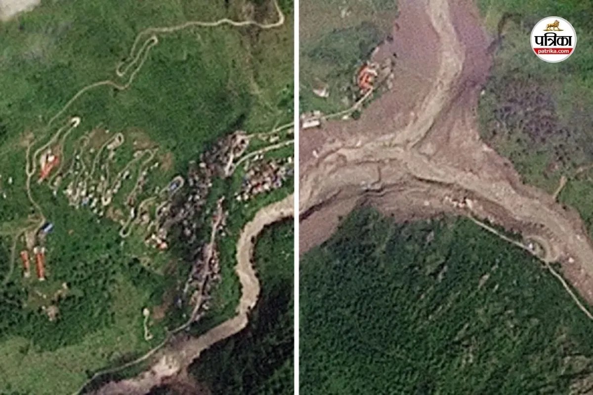
You don't fully grasp the raw fury of a mountain until you see an entire community wiped off the map before breakfast. When a massive glacier collapsed across the border in Tibet, sending a wall of water and debris crashing down the Lhende river valley, it didn't just flood towns. It erased them. Satellite imagery from Planet Labs captured the horrifying transformation, showing how terrain that once bustled with homes and roadways turned into sprawling fields of grey mud and jagged boulders.
Official reports and rescue agencies point to a staggering human toll. Nepal Police confirmed hundreds of fatalities, while well over a thousand individuals remain missing in the rugged terrain of Rasuwa and surrounding districts. When you look at the mechanics of this disaster, the speed of the catastrophe is what haunts survivors the most.
The Anatomy of a Himalayan Flash Flood
People often assume floods build up over days of heavy rain, giving folks time to pack bags and head for higher ground. This disaster didn't play by those rules. At roughly 8:40 in the morning, a high-altitude glacier gave way near the Tibet region, dumping an ungodly amount of ice, snow, and rock into the river basin.
This massive debris blocked the natural water flow, creating a temporary, highly unstable natural dam. When that blockage finally burst under immense pressure, a catastrophic wall of water surged across the border into Nepal.
- The Lhende river crashed into the Bhotekoshi and Trishuli river systems.
- Water levels in the Trishuli river spiked by nearly thirty feet in just thirty minutes.
- Vital infrastructure including nineteen motorable bridges and roughly forty kilometers of roadways simply vanished.
Local officials who were stationed to sound the alarm didn't even stand a chance. The water moved too fast, sweeping away the very people tasked with warning the valley. Rescue teams arriving at Syaprubesi and Timure found themselves battling blocked paths, destroyed bridges, and an unrecognizable landscape where villages used to stand.
Why Traditional Disaster Prep Failed Here
You can’t outrun a thirty-foot wall of water arriving with zero warning. Mountain communities live with the constant, quiet threat of glacial lake outburst floods, but knowing a threat exists on paper doesn't stop physics. The remote geography of the region turns every rescue operation into a nightmare. Choppers can't land where helipads are buried under twenty feet of fresh mud. Heavy machinery can't reach cut-off zones because the roads connecting them have tumbled down into roaring torrents.
The ripple effects stretched far beyond the initial impact zone, affecting districts like Nuwakot, Dhading, Gorkha, Tanahu, Chitwan, and Nawalparasi as the swollen Trishuli transformed into the Narayani river further downstream. International tourists, local villagers, and cross-border traders got caught in the crosshairs. Hundreds of citizens from neighboring countries, including India, found themselves stranded or missing as communication lines went completely dark.
What Happens When the Mud Settles
Recovery efforts face a grim reality check right now. Hospitals in surviving pockets are running low on vital medical supplies. Survivors sift through thick sludge, searching for scraps of personal belongings or livestock that didn't make it. Ministers on the ground describe affected zones as looking less like human settlements and more like desolate, reshaped deserts.
If there's any hard lesson to take away from this tragedy, it's that climate shifts and high-altitude warming are rewriting the dangers of the Himalayas. These aren't routine seasonal monsoons. These are structural, landscape-altering events that demand a complete rethink of how we monitor remote glacial regions before they snap.
Check your local emergency protocols if you're traveling through border regions, support verified relief funds working on the ground in Rasuwa, and stop treating mountain ecosystems as predictable backdrops. They talk back, and sometimes they roar.